


arsel chasserades au bleymard

labarone
User
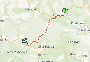

Length
14.1 km

Max alt
1451 m

Uphill gradient
517 m
Km-Effort
21 km

Min alt
1069 m

Downhill gradient
613 m
Boucle
No
Creation date :
2020-09-09 06:49:36.279
Updated on :
2020-09-09 13:04:25.744
6h14
Difficulty : Very easy

FREE GPS app for hiking
 SityTrail
IGN / Geographical institutes
SityTrail Plus
The world is yours!
About
Trail Walking of 14.1 km to be discovered at Occitania, Lozère, Mont Lozère et Goulet. This trail is proposed by labarone.
Description
cool
Photos


Positioning
Country:
France
Region :
Occitania
Department/Province :
Lozère
Municipality :
Mont Lozère et Goulet
Location:
Unknown
Start:(Dec)
Start:(UTM)
566018 ; 4933298 (31T) N.
Comments